Chapman Road Tactical Urbanisation Pilot Project
The RAC funded Chapman Road Tactical Urbanism Pilot Project is a 12 month long trial that tests reconfiguring Chapman Road in the CBD and activating the street by turning it into a place for people and not just cars. The trail began in September 2021 after the works to activate the street were completed. More here
The goals of the projects are to reduce traffic speed, improve pedestrian and cyclist safety whilst enhancing movement networks, increase streetscape amenity including outdoor dining options and create a more shaded and a comfortable pedestrian environment which will increase visitation to the area by residents and tourists. If the activation doesn’t work out, at the end of the 12 month trial, the street can be easily returned to its original state.
The final transformation of the street between Cathedral Avenue and Durlacher Street took only two weeks to complete. More here
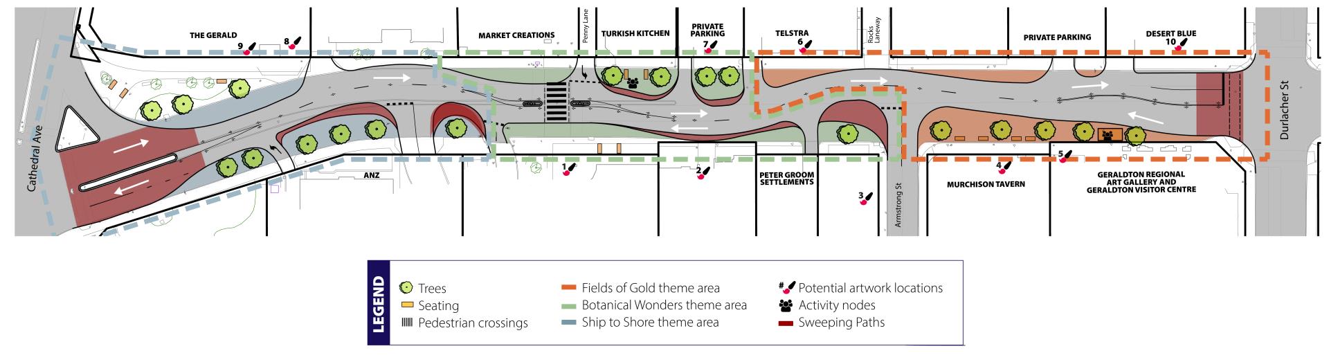
The plan involved reclaiming and then activating this section of the road in the following four stages:
1.Removed the median strip, restoring the road surface and line marking the road to formalise the two lanes of two-way traffic.
2. The reclaimed street was painted blue, green and orange representing ocean, botanic and outback respectively.
3. Bench seating and large potted trees was installed in the painted pavement areas and a parklet was placed in front of the Geraldton Regional Art Gallery Park.
4. Various artworks which have been created by local artists including selfie walls, Aboriginal artworks on shop front windows and a series of art loving critters who have stolen art work who are hiding along Chapman Road were installed. More on the artists and art works here
Activation Plan Design
Background
Draft Tactical Urbanisation Action Plan
Is the community involved in these changes?
What is tactical Urbanism?
Whose idea was it to reconfigure lanes on the street?
Who came up with the plan?
Frequently asked questions
Background
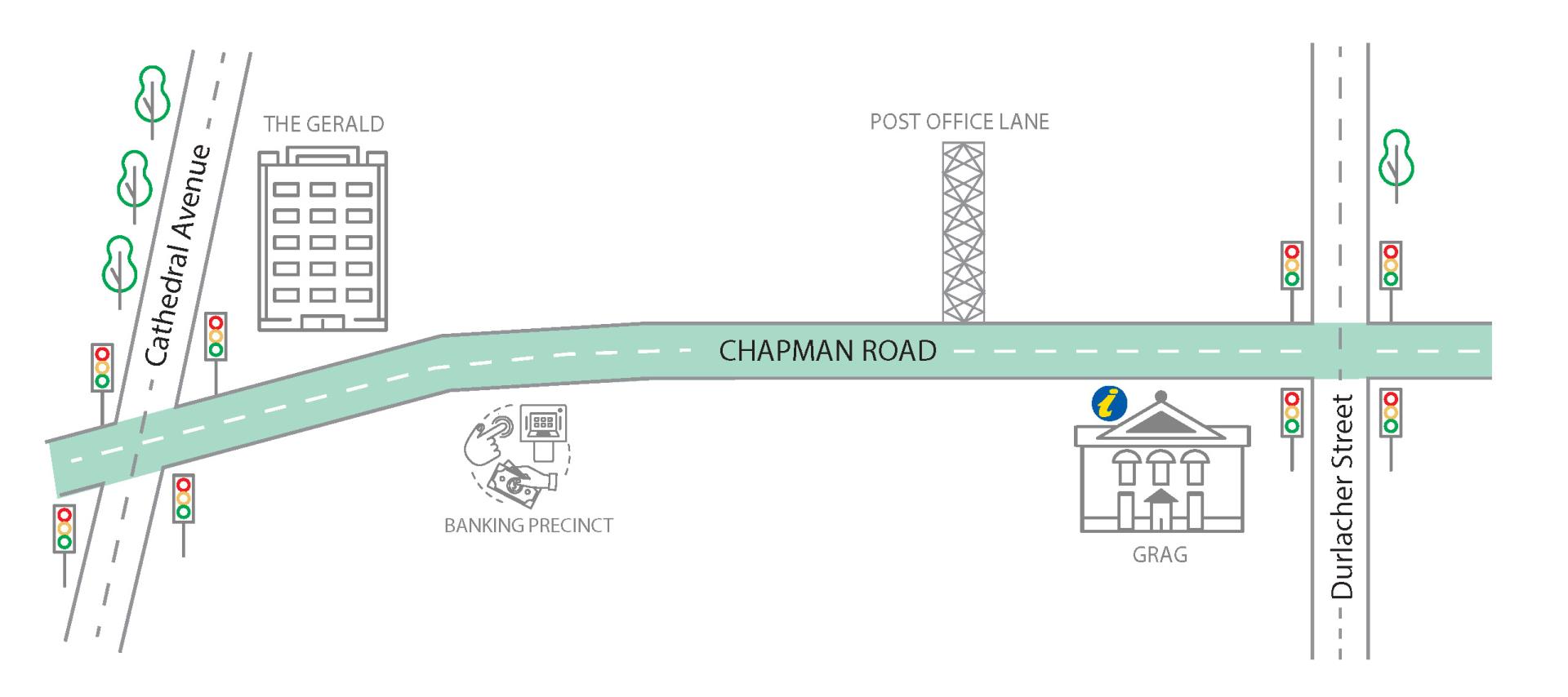
The pilot project is part of the Geraldton City Centre Revitalisation Plan which involves ongoing works to expand the CBD’s role beyond a business district, to become the tourist and entertainment precinct on the Midwest. There are number of businesses on this street that would benefit from activation including retail outlets, a restaurant, a takeaway food business, the Art Gallery, the Visitor Centre and a hotel. Activating the street will make it more vibrant and may attract new businesses and investment which will in turn, increase visitation to the area from residents and tourists alike. Download the pilot project newsletter here
Map of Project Area.
Check out the 3D Fly Through Vision of our revitalised CBD here
The City has received an $80,000 grant from the RAC and delivered the project in partnership with the organisation through its Reconnect WA initiative which aims to create vibrant streets and public places for Western Australians to interact and connect. Read more in the media release here
Tactical Urbanisation Action Plan
An Action Plan to activate the street was developed. Read the Plan here
Is the community involved in these changes?
Yes, the City work with schools and local artists to develop art work for the project. Watch the City's Facebook page and our website for more information on the art and artists.
What is tactical urbanism?
Tactical urbanism, is about repurposing under utilised places by creating comfortable and exciting spaces and streets for people to enjoy using low-cost temporary materials such as tree planters, parklets, art, widened footpaths, pop-up bike lanes and improved road crossing opportunities to create a safer, more pedestrian friendly streetscape that adds vibrancy to an area. The project involves the section between Durlacher Street and Cathedral Avenue will be activated
Whose idea was it to reconfigure the traffic lanes on Chapman Road and activate the street?
In 2017, Council adopted the Geraldton City Centre Revitalisation Plan which identified an opportunity to formalise two lane traffic on this section of Chapman Road and activate the street. This project was included in the Plan as the width of Chapman Road does not meet the minimum road with requirements for it to be four lanes wide, which is why it isn’t marked as such. Narrowing and formalising the road into two lanes will reduce traffic speeds, make it safer for cyclists to use and safer for people trying to cross the road.
Who came up with the Action Plan?
The draft plan has been developed by a Working Party of 18 local business operators and property owners, community group members, youth, Main Roads WA and other interested parties. After the group was upskilled in contemporary place-making practices and the tactical urbanism approach to change, they utilised the results of the Ideas Competition held in early March to develop the Draft Activation Plan. Read the Activation Action Plan here
Frequently Asked Questions
Download project FAQs here
Reconfiguring Chapman Road
Trees and seating
Road art and murals
What if the changes don't work?
Streetscape photos
Reconfiguring Chapman Road
Won’t reducing the road to two lane traffic only increase traffic congestion in the area?
As the road isn’t wide enough for, nor is it line marked as four lanes and many drivers currently use the 250m long stretch as a two lane street. When vehicle acceleration and deceleration and a 50km/h speed limit is taken into consideration, it only takes on average about 30 seconds to travel along this stretch of road. Computer traffic modelling shows formalised two lane traffic won’t lead to an increase in congestion as drivers interested in saving time could use a number of potential alternative routes in the area. Since completion of the Durlacher and Cathedral Avenue roundabouts, traffic flow along these alternative routes has also greatly improved.
How will vehicles go from two lanes at the Durlacher Street intersection to one lane on Chapman Road in front of the Art Gallery?
The two lanes will merge into one in front of the Geraldton Regional Art Gallery. Main Roads WA have approved this design.
What will happen to the median island?
It will be removed to reconfigure the two lanes of two way traffic.
Why does the road have a snake like appearance?
The snake like design of the road reduces driver sight lines, which helps reduce traffic speed.
What will happen to the bus stop?
The bus stop will will be relocated further south, in front of the property settlement agency.
What will happen to the loading zone?
The loading zone will me moved slightly to the north in front of the the legal services office on the corner of Armstrong Street.
Will Woolworth’s delivery trucks still be able to access Armstrong Street?
Yes, the City has worked with the retailer, road engineers and Main Roads WA to ensure trucks will still be able to safely enter and exit Armstrong Street.
Trees and Seating
What is the purpose of the trees in pots?
The potted trees will help define and separate the two lanes of traffic from the shared pedestrian and cyclist areas. One of the goals of the City Centre Revitalisation Plan is to increase the tree canopy in the CBD. Adding 20 more trees helps achieve this goal.
What kind of pots will be used for the street trees?
The City will be repurposing 20 planter boxes for use in the project.
What kind of trees will be planted in the pots?
Trees that provide a fair amount of shade and thrive in the planter boxes will be used.
Why are parklets included in the draft design?
Parklets are public open spaces that provide a shaded place for people to meet, sit, relax and even enjoy takeaway food or drinks. Shaded seating is essential if you want to attract people and encourage them to and stay for a while.
Road Art and Murals
What is the purpose of the road art?
The road art helps define the traffic lanes from the reclaimed roadway that will be turned into a shared pedestrian space whilst bringing the street to life.
Do the coloured road areas in the final design mean anything?
Yes, the blue green and orange represent ocean, botanic and outback respectively.
Have the designs for the wall murals already been chosen?
Yes. Local artists have been engaged to design the selfie walls. The designs will be released soon. More on the artists and art works here
Who decided where the wall murals would be located?
The locations were chosen for their high visibility to people passing by. The City worked with building owners regarding these sites.
Who will paint the wall murals?
To ensure high quality artwork is added to these buildings and the artwork is ‘Instagramable’ the artists whose designs were chosen will be paid for their artwork.
What will happen if these proposed changes just don’t work?
The benefit of trialling temporary changes using low cost materials and items that can be easily moved around is to see if the ideas actually work. If not, the design can be modified and changed to test other ideas. If none of the options work, at the end of the trial the street can be easily returned to its original state.
Is there much community support to revitalise the CBD?
Yes! Recent engagement with the community regarding future of the City prioritises economic development which includes the revitalisation of the CBD. Economic development including the revitalisation of the CBD was the top ranking future priority in the Community Voice Survey conducted in 2020. According to youth who participated in a series of World Cafés over the last 14 months, creating a vibrant retail and restaurant sector in the CBD was the second best way the City could be made an even better place to live.
Have any revitalisation works been done yet?
The transformation of the CBD began shortly after the Geraldton City Centre Revitalisation Plan was adopted by Council in June 2017. Projects already completed include CBD Underground Power, the Rocks Laneway, Durlacher Street Roundabout, Cathedral Avenue-Sanford Street Roundabout, Art-Covered Bollards and the Parklet Trial.
Chapman Road Streetscape