Railway Street - Safe Active Street
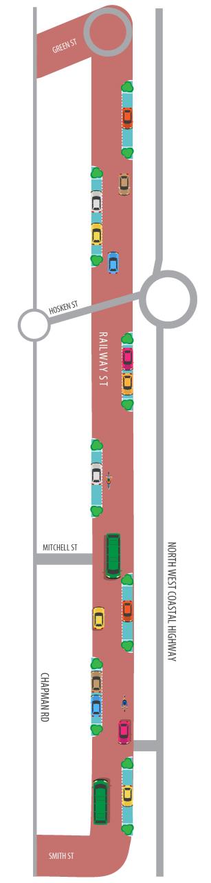
The Department of Transport and the City have transformed Railway Street in Bluff Point, from Smith Street to Green Street, into a safe active street. This was a pilot program for Department of Transport and the first of its kind in regional Western Australia.Construction of the 1.4km long safe active street began on 28 September 2021 and was completed in June 2022. More here
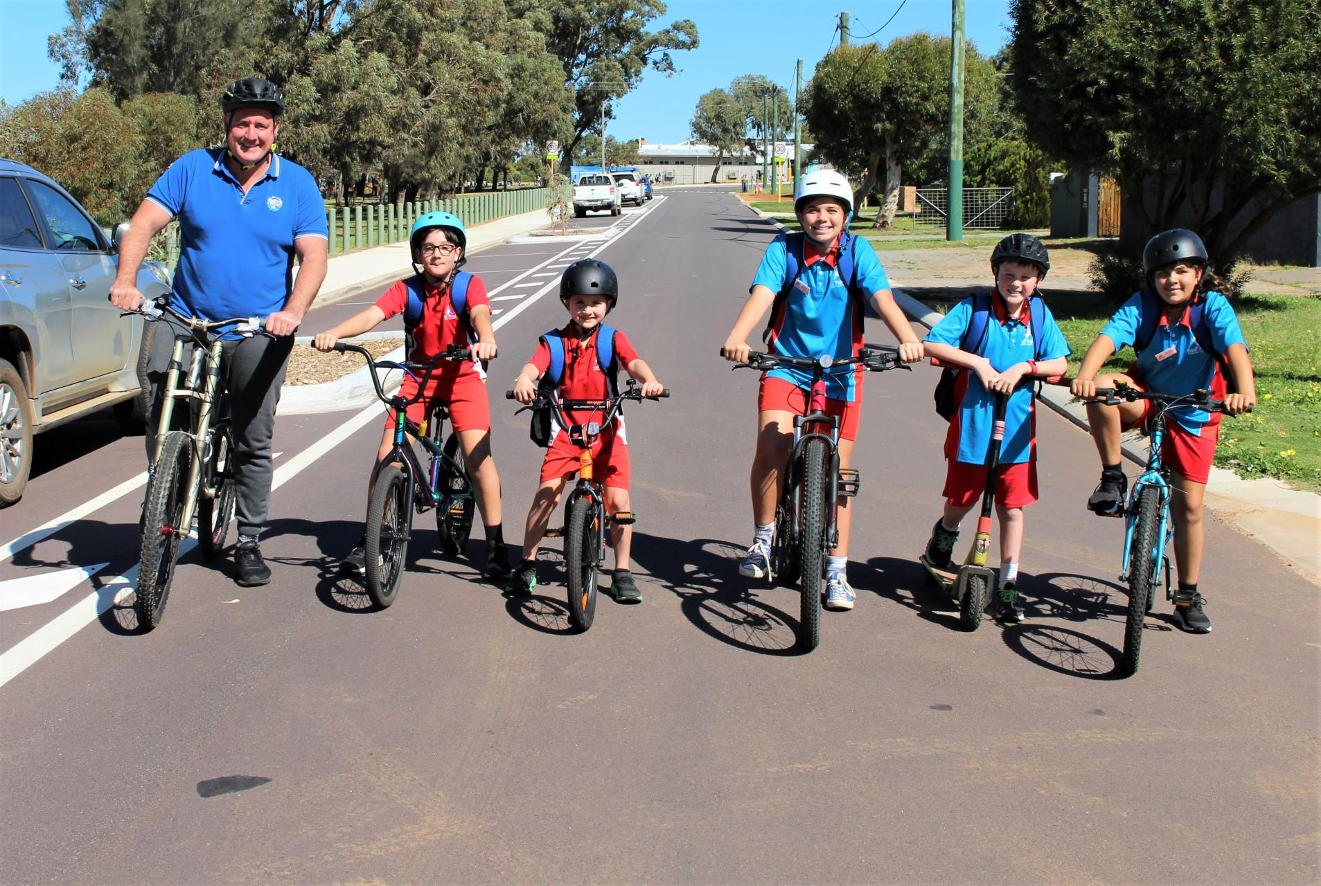
Image: Mayor Shane Van Styn with Bluff Point Primary School students.
What is a safe active street?
A safe active street is a quiet, low traffic, low speed, local street, that is designed to be a more welcoming space for all road users including riders, walkers and drivers.
These streets offer an active transport route from areas where people live to nearby parks, schools and business.
How is traffic slowed down on safe active streets?
The speed limit on Railway Street has been reduced to 30km/h and raised plateaus have been installed to slow down vehicles.
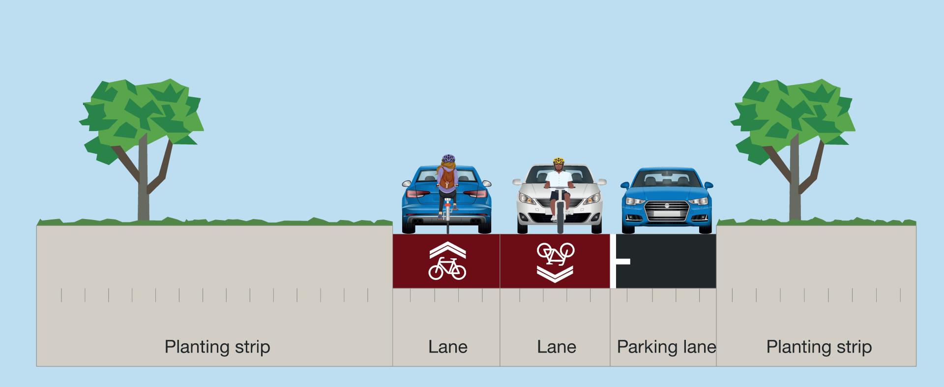
The generous street width has been divided into three lanes; two for drivers and one for designated on-street parking. These parking bays, that are bookended with street trees, also alternate sides of the street.
The resulting ‘snaked’ road helps slow vehicles down, making it safer for people to share.
How do buses fit in?
Railway Street is still wide enough for two vehicles, including buses, to pass each other with cars parked in the designated on street-parking bays.
Project Background
Railway Street was identified as a potential site for the project in the Geraldton 2050 Cycling Strategy.
The safe active street connects to the existing path network in the Chapman River Regional Park via a 500m long shared path at Green Street. Once inside the Park, a network of shared paths enables walkers and riders to travel along the west of North West Coastal Highway back to Green Street and north to shared paths that will soon be extended all the way to Drummond Cove.
The Railway Street safe active street is an important part of the City's Integrated Transport Strategy that looks to provide more options for short trips and the daily commute. The Heart Foundation also recognises the importance of cycling and walking and is calling on local governments to allocate extra street and footpath space for people walking, and riding bikes. More here
More information on the Safe Active Streets Program can be found on the Department of Transport's website here
Download Fact Sheet here
The total project cost was $1.73 million with the Department of Transport contributing $1.1 million in grant funding and the City the remaining $630,000.

Frequently Asked Questions
Who benefits from the safe active street?
The landscape of Geraldton is ideal for walking and cycling, and the provision of accessible community spaces that equitably service the whole community are identified in the City’s Strategic Community Plan. Safe active streets aim to make streets safer for all age groups, with emphasis on increasing opportunities for active transport by designing inviting spaces for people to walk and ride bikes, rather than just thoroughfare.
How will people know they are on a safe active street?
The safe active street is paved in red asphalt. The entry points feature blue-and-white road patches, 30 km/h speed limit signs and raised plateaus help to slow traffic and alert people that they are in a bicycle and pedestrian friendly space. Street trees have been planted to improve the overall amenity and make the street a more attractive place to walk, ride and drive.
Will the safe active street discourage rat running?
We recognise Railway Street is being used as a rat run between the North West Coastal Highway and Chapman Road. While the street provides an important local connection and cannot be closed. While rat running is a broader local area traffic management issue, the traffic calming measures on the safe active street, including the reduced speed limit, raised plateaus and a reduced road width will discourage rat running.
Will there be big groups of fast cyclists riding down the street?
Not likely. The proposed roads do not form part of a designated route for established group rides, which typically use more direct major roads. Safe active streets are ideal for slow speed riding. The street context and design, including raised plateaus and slow points will not encourage groups of fast moving recreational cyclists.
How does the Safe Active Street Project fit into the State’s transport network?
Greater Geraldton has all the ingredients needed for a great cycling and walking city – a warm climate, flat topography and outstanding natural beauty. As the city’s population increases and more people live near centres of activity, walking and cycling can play a big part in helping to reduce congestion, improve air quality, support local business and encourage a healthy, active lifestyle. The Transport Portfolio is ensuring more emphasis is being placed on providing high-quality, safe and comfortable cycling infrastructure that is integrated with public transport services. There are a number of different types of cycling infrastructure that contribute to the make-up of the cycling network including on-road paths, off-road paths, river crossings and safe active streets.