Chapman River Trails Survey
It’s been nearly eight years since the Chapman River Loop trail located in the Chapman River Regional Park was formalised.
Therefore, the City is seeking feedback from the community about when and where you go and what you do on the trails in the Park. We also want to know if you've experienced any safety issues or concerns while on the trails and if you have any suggestions for improvements to the shared Loop Trail.
Be sure to check out the Trails FAQs below before you take the online survey.
Paper copy surveys are available at the Civic Centre.

Trails Frequently Asked Questions
The Chapman River Regional Park (CRRP), approximately 364ha in size, begins at Cutubury Reserve in Moonyonooka and ends downstream at the Chapman River Estuary at the river mouth. The Park is Crown Land that is managed by the City via a Park Management Plan that’s been in use for more than 25 years.
How many trails are there in the Park?
Who can use the trails?
Can I walk my dog in the Park?
Are e-Scooters and e-Bikes allowed on the trails?
Are dirt motor bikes allowed on the Park?
What are the trail ratings?
Are the trails accessible for wheelchair users?
There are so many beautiful flowers in the park can I take a few home with me?
Can the City provide any information on the plants and animals in the Park?
Why was the Shared Use Loop Trail created?
When did the mountain bike track become the Loop Trail?
Who created and maintains the Loop Trail in the CRRP?
The Loop Trail isn’t very challenging in some spots, can it be changed to make it more technical?
Can additional, more technical mountain bike tracks be created in the Park?
Are there any other areas in Greater Geraldton where more technical mountain bike tracks can be constructed?
Why aren’t there any pedestrian/cyclist bridges at the east and west ends of the Park?
Who do I contact if I have a safety concern related to the trails network in the Chapman Regional Park?
FAQs
Download a copy of the FAQs below here
How many trails are there in the Park?
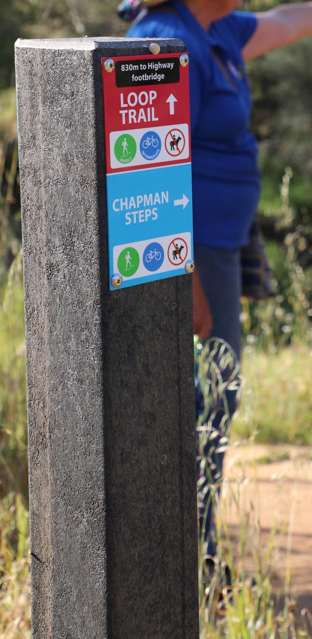
There are five trails within the Park with options ranging from short 1km long trails to the 11km long shared use Loop Trail. There are also a number of tracks throughout the Park that can also be used. For more information please read the Chapman River Reserve Walk Trails Brochure
Who can use the trails?
Although there are a variety of trails on the Park suitable for walkers, mountain bike riders and horse riders only the Loop Trial is designated for shared use by Council. Service tracks can also be used by mountain bike and horse riders. Trail way markers are located throughout the Park to direct users to the appropriate trails.
Can I walk my dog in the Park?
Yes, but dogs must be kept on a leash at all times.
Are e-Scooters and e-Bikes allowed on the trails?
Yes, legally compliant e-Ridables are only permitted on the Loop Trail, Esturary Trail or service roads. Wattle Walk, River Walk and Jennas flora Walk are walking trails only.
Are dirt motor bikes allowed on the Park?
No, motor bikes are not permitted anywhere in the Park.
What are the trail ratings?
The trails are rated Grade 3 walk trail (Australian Standard 2156 Walking tracks - Classification and Grading System), and Moderate – Blue mountain bike trail (WA Mountain Bike Management Guidelines). The Estuary Trail is rated Grade 2.
Are the trails accessible for wheelchair users?
Yes, A trekking wheelchair is available for hire through ATLAS and can be used for various parts of the Loop Trail. Please contact ATLAS on 0408 946 880 or email atlas@sportshouse.net.au for more details. The Estuary Trail (Grade 2) is suitable for all standard wheelchairs.
There are so many beautiful flowers in the park can I take a few home with me?
Unfortunately, No. It is illegal to remove plants from the park. Leave only footsteps, take only photographs and please stay on the trail.
Can the City provide any information on the plants and animals in the Park.
Yes, the City’s website has a lot of information available here. Geraldton is lucky to have a very passionate group of volunteers, the Chapman River Friends, that lead guided wildflower walks during the wildflower season. They have also developed a free CRFwildflower ID app which can be used to identify many of the park’s plants. Available to download on Google Play or Apple Store.
Why was the Shared Use Loop Trail created?
The 11km Shared Use Loop Trail was designed to provide a positive environmental benefit through the implementation of an environmentally sustainable trail design. It provides mountain bike users with a cross-country moderate blue level trail reducing cut throughs and spur trails which were damaging the surrounding environment.
When did the mountain bike track become the Loop Trail?
In November 2016, Council endorsed the Chapman River Regional Park Mountain Bike Masterplan that detailed the formalisation of the existing mountain bike track through the Park into what is now the shared access Loop Trail.
Who created and maintains the Loop Trail in the CRRP?
The City engaged Common Ground Trails to formalise the shared use loop trail. The City maintains the 11km formalised shared use Loop Trail, service roads and informal trails. Members of the Geraldton Spokes Mountain Bike Club and Chapman River Friends are currently in the process of developing a community partnership agreements with the City to undertake minor maintenance to assist in the protection, enhancement and regeneration of the wildlife corridor.
The Loop Trail isn’t very challenging in some spots, can it be changed to make it more technical?
During consultation, the mountain biking community prioritised dual direction use of the trail over the introduction of technical elements on a single direction trail. When Council endorsed the CRRP Masterplan it specified the trail be constructed to a standard that caters for recreational cycling activity by people with moderate skills and variable fitness. It is not intended for ‘sport, independent and gravity’ level mountain bike activities.
Can additional, more technical mountain bike tracks be created in the Park?
The Park is considered an area of high conservation value. As such the Environmental Protection Act 1986 and the Environment Protection and Biodiversity Conservation Act 1999 requires the City to protect the Park’s high value flora and fauna.
Are there any other areas in Greater Geraldton where more technical mountain bike tracks can be constructed?
The City has investigated the land it owns/manages for suitability and found that none met the requirements to create a more technical track (i.e. lacks required elevation for a gravity rides, soils are too sandy, etc.). The City has also investigated a number of potential sites that are owned/managed by State Government agencies, however, these agencies do not support their sites being used for these purposes.
Why aren’t there any pedestrian/cyclist bridges at the east and west ends of the Park?
The investigation into a bridge at the eastern end of the Loop Trail was undertaken in 2020 and was added to the City’s Capital Works Program. Given the flood design requirements for the bridge the cost to build a bridge is prohibitive. An existing bridge to the west provides a winter crossing for the trail, shortening the experience by a few kilometres.
Who do I contact if I have a safety concern related to the trails network in the Chapman Regional Park?
For any queries or concerns please contact City Officers on (08) 9956 6600 or email council@cgg.wa.gov.au