Beresford Foreshore Enhancement Project
The transformation of the Beresford Foreshore has been completed and the popular 1.8km long stretch of coastline was officially reopened to the public on 25 October 2018. The enhancement of the Foreshore began in January 2018. More here and here
Background
The enhancement of the Beresford Foreshore followed the completion of coastal protection works that were implemented to protect the rapidly eroding shoreline. More here
The Coastal protection works were the result of a seven year collaboration between the City of Greater Geraldton, Department of Transport and Mid West Ports Authority assisted with funding contributions by the Mid West Development Commission over the past seven years on the development of a coastal protection strategy for the Beresford Foreshore - the area north of the Geraldton Port and Batavia Coast Marina structures. More here
The foreshore enhancement designs were developed in close consultation with the community through a survey, workshop and community information session. The detailed designs include their top 15 priorities for the Foreshore which involved upgrading the shared coastal cycle path to a promenade, planting more trees and shrubs, and installing more shade structures, seating and tables. More here
The Master Plan Concept Designs were presented to the community in July 2017. See the Master Plan here
Project Funding
The $23.1 million Beresford Foreshore Coastal Protection and Enhancement Project was jointly funded by the State Government Regional Grants Scheme project managed by the Mid West Development Commission and the Mid West Ports Authority with the City contributing $1.8 million in funding towards amenities.


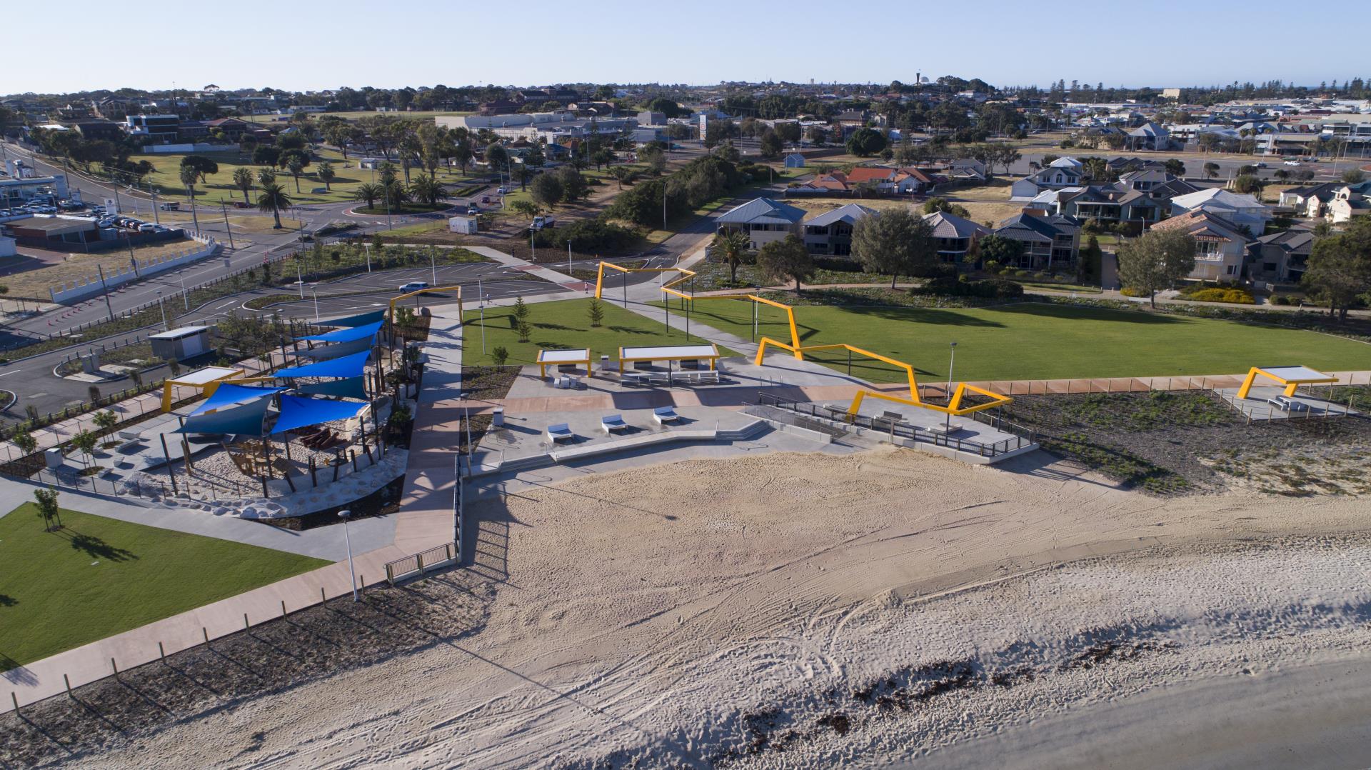
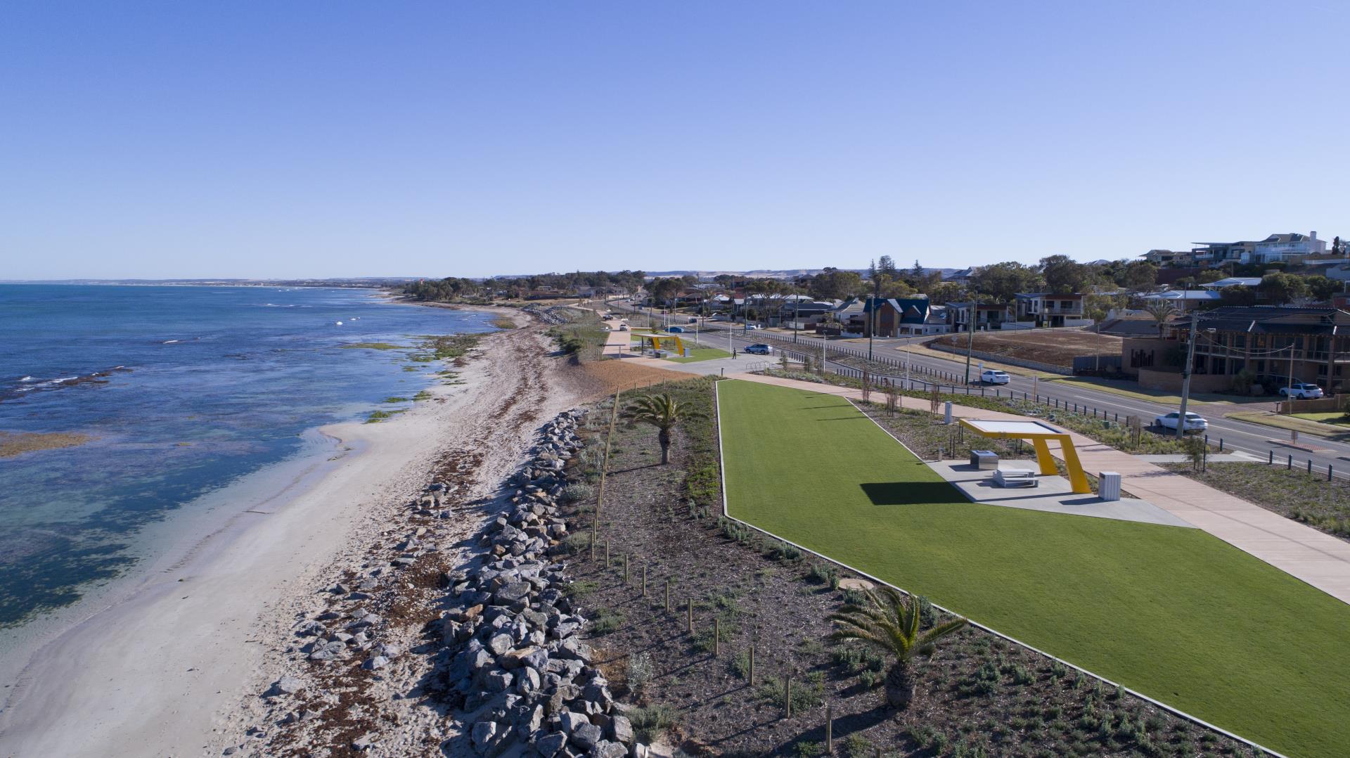
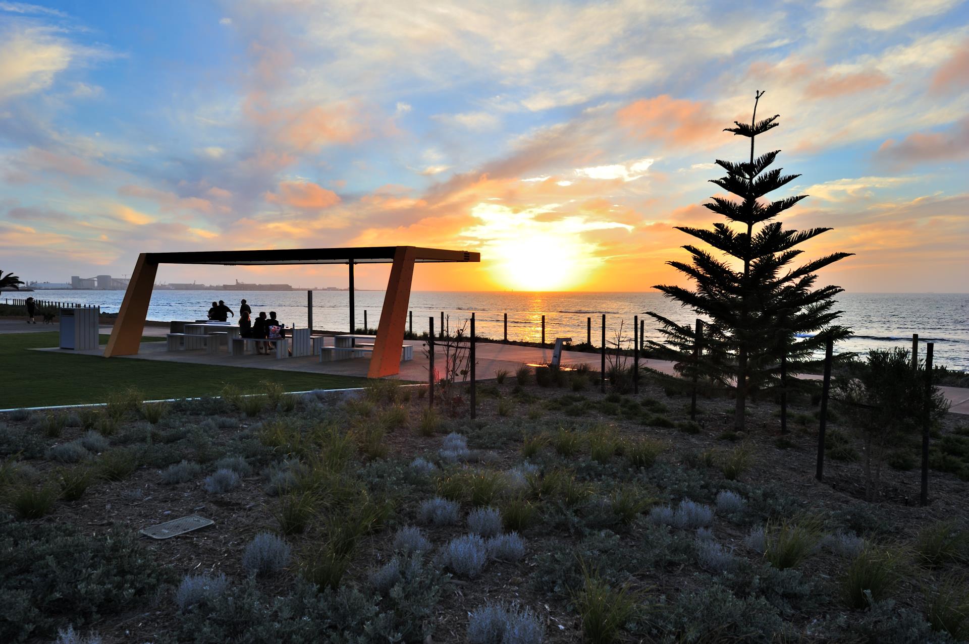
The Completed Project
Midalias Beach featuring a nature playground.
The Mark Street Node
Beresford Foreshore at Sunset
Frequently Asked Questions
How do we lobby the State Government regarding the power lines being placed underground?
Members of the community who support underground power lines along the Beresford Foreshore can lobby the State Government by contacting either local elected member Mr Ian Blayney MLA or Member for the Agricultural Region Mr Darren West MLC.
Why doesn’t the path follow old railway line to the south and north to Bluff Point?
At the north end of the Beresford Foreshore the former railway line leaves the Foreshore as it crosses Chapman Road at Ord Street and continues in an easterly direction towards the North West Coastal Highway. Therefore, it does not provide a link to Bluff Point. At the south end of the Beresford Foreshore, the land on which the former railway lies belongs to the Public Transport Authority and therefore, cannot be developed by the City.
There was a small sandy bay at Dean Street where everyone swam, what protection is there to the particular reef area at this spot?
The bay still exists and the Foreshore in this area will be protected by an onshore revetment structure.
There is an existing heritage monument between Adam Street and Mabel Street that identifies an historic metal post embedded in the reef. Will it be retained?
The City has met with local historians to confirm the historical significance of the metal post embedded in the reef. Up to now, there has been no clear confirmation as to what the metal post represents. Investigations are still underway.
Rather than hand back the money, could this go to St Georges, Sunset and Drummonds that also require intervention?
The City is currently exploring avenues with the State Government to determine if unspent funding could be implemented for projects along the northern coastline.
What will happen to water flow through the bay?
Water still flows in and out of Midalia’s Beach. The breakwater extensions are designed to reduce the energy of the waves. This will help keep beach sand within Midalia’s Beach. Water flow through Champion Bay will be unaffected. The rear-of-beach revetments do not interfere with the natural coastal processes.
Although the road is not really wide enough, will there be a bus stop?
The Public Transport Authority determines where bus stops will be located, not the City. However, should there be an increased demand for further public transport stops along the Foreshore the City would advocate for this added service.
Have high and low tides been taken into consideration so we have beach all year round?
The design of the coastal protection structures has taken into account the various tide levels throughout the year. The amount of beach available on any given day will be subject to the tide at the time.
Will the Memorial Seat at the steps to the beach at Mark Street be replaced?
This will be considered by the design team however, it is the intention that all memorial items will be retained.
How wide will the beach areas be north of Midalia’s Beach?
This will be determined by the tidal conditions of the day.
How big will the toilet block be?
The toilet block will be similar to the ones the City has previously built at Back Beach, Glendinning Park and Derna Park which features four unisex and one universal toilet.
Will the design or structure of the toilet block cater for our formidable winds?
Yes, environmental, health and safety will all be considered during the design process.
What types of trees will be planted?
Revegetation will feature natives and plants that are well suited to the harsh coastal climate and limited availability of water.
Will dogs on leads be allowed? Could the beach north of Midalia’s Beach be lead free, even if it was before 8am and after 4pm?
Currently, dogs must be on leads at Midalia’s Beach and along the Beresford Foreshore. There are no plans to change this.
Will water fountains also have dog bowls?
The design team has been requested to include these as part of the beach shower and water bubbler arrangements to be included along the Foreshore.
Will there be CCTV?
The design team will be considering provision for CCTV in the Midalia’s Beach area.
Is there protection for the two small copious of trees there now? Why are they not fenced?
The City is keen to keep and incorporate the existing trees in the landscape of the Foreshore. For example, the palm trees at Dean Street will be retained. Coastal protection construction works are being monitored and contractors have been advised to avoid vegetation that is not directly impacted by the required works.
What are defined as shade trees? What types of trees will be planted?
The types of trees that will be planted are still being determined and will take into consideration their ability to provide shade for people using the Foreshore area. Tree types chosen will be well suited to the harsh coastal climate and limited availability of water. The palm trees at Dean Street will be retained.
When will trees be planted and will they be irrigated?
Revegetation works at Midalia’s Beach are already underway; however, further revegetation works will not take place until autumn 2018, which is the optimal time to plant trees and shrubs. Vegetation will be initially irrigated to assist with the establishment of the plants, which typically takes one to two years. Once this has occurred the reticulation will be removed.
What is the elevation of the path? Is it flat along the beach?
This is yet to be confirmed however, the aspiration is for the path to respond to subtle changes in the Foreshore topography while following the alignment currently shown on the masterplan
How wide will the path be?
This is still to be confirmed but current expectations are of 4-5m to respond to the scale of the Foreshore.
What is the risk of inundation?
Inundation maps can be found in the Town Beach to Drummond Cove Inundation report available on the City’s Website here The maps are based on the pre-protection project coastline. Minor inundation may still occur along the post protection coastline where there are no protection structures.
What is the access run at north and south ends of the Foreshore?
Members of the community will be able to access the north and south ends of the Foreshore promenade via Chapman Road. The existing access to Midalia’s Beach via the Beagle Place carpark and footpath will remain unchanged.
The ongoing works at the Beresford foreshore project have resulted in sediment being suspended in the inshore marine environment. This sediment plume has changed colour over time from pale to grey. The sediments appear to moves northwards with currents and appear to cover a large area of Champion bay and beyond. Has the impact on wildlife, including the threatened Australian Sea lion and seagrasses been taken account of in the environmental impact assessment of the Beresford Foreshore Project?
A Construction Environmental Management Plan (CEMP) was required to be prepared by the successful tenderer for implementation prior to the Beresford Coastal Protection works commencing. The CEMP for the works was produced for the Contractor by a qualified environmental consultant experienced in producing CEMP documentation for marine and coastal projects. The CEMP sets out to ensure that any erosion or sediment control is managed so as not to significantly impact on the Beresford Foreshore environment. During construction and rock placement, small fines were expected to be released into the marine environment causing a visible sediment plume. The City and Mid-West Ports Authority regularly cart sand to the Beresford Foreshore as part of annual sand renourishment program and a plume is often seen during this time for a short period.
The CEMP generally addresses environmental management of the following key areas:
- Sourcing of sand beach fill with the required particle-size requirements;
- Undertaking background turbidity sampling to identify baseline pre-construction turbidity levels;
- Regular testing to ensure that the turbidity is within the planned tolerances of the baseline samples;
- Regular site observations and photographs of the works area; and
- Water quality monitoring at the baseline monitoring locations for observed plumes.
Noting that that sand beach fill activities are now complete at the Midalia’s Beach site, turbidity testing to date has been within the tolerances specified within the CEMP and the measured water quality has been acceptable in the observed plumes. It should also be noted that regular disturbance and transport of seabed sediment from natural wave action and coastal processes occurs in this area and beach works for the revetments are also providing a source of sand for sediment transport through natural wave action in the swash zone.
Is a copy of the environmental plan publically available?
The Construction Environmental Management Plan forms a part of the contract documentation and is of a commercial-in-confidence nature as the Intellectual Property is owned by the contractor and therefore, not publically available.
If marine monitoring has been conducted to track sediment loads will the results be made public?
The Construction Environmental Management Plan forms a part of the contract documentation and is of a commercial-in-confidence nature as the Intellectual Property is owned by the contractor and therefore, not publically available.
Rainwater runoff from the hill impacts Chapman Road. Will the issue at the corner of Mark Street be addressed?
This item is not included in the current Foreshore scope however, it will be forwarded to the City maintenance department for investigation.