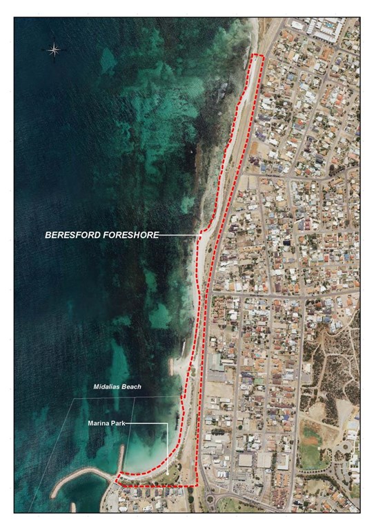
Beresford Foreshore Project - Background
 |
| Beresford Foreshore |
Detailed Engineering Design
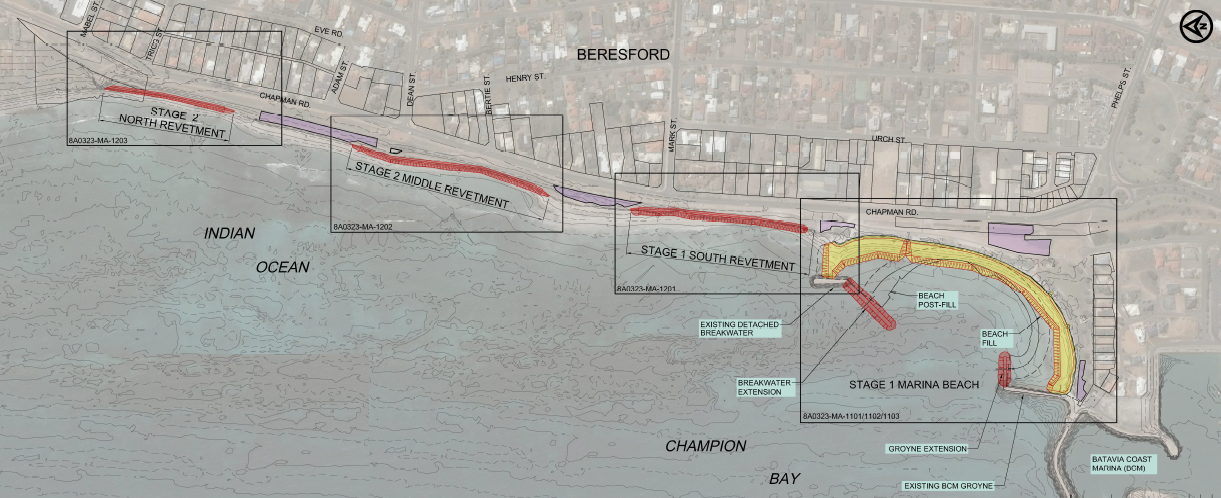 |
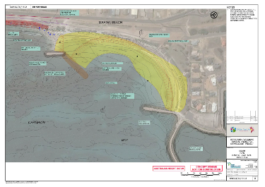
| Figure 1 - Beresford Foreshore Final Engineering Design |
The City of Greater Geraldton, Department of Transport (DoT) and Mid West Ports Authority (MWPA) assisted with funding contributions by the Mid West Development Commission (MWDC) have collaborated over the past seven years on the development of a coastal protection strategy for the Beresford Foreshore - the area north of the Geraldton Port and Batavia Coast Marina structures.
Guided by a State Government ministerial working group, the detailed engineering design solution for reducing the impacts of erosion on the Beresford Foreshore is now complete (Figure 1). Based on a Council Resolution the detailed design was adopted on 27 October 2015. The design include extensions to the offshore breakwater and marina groynes with a large initial nourishment of sand to Midalia Beach. In addition, three revetments (or sea walls) will be sited further north along the foreshore. The construction of these revetments will require earthworks to stabilise areas damaged by erosion. Subsequent work will give rise to the repair or replacement of damaged paths, landscaping and building of amenities.
The detailed engineering design was developed by Royal HaskoningDHV, an internationally recognised coastal engineering consultant.
You can view the project final engineering solution and detailed design report by Royal HaskoningDHV below:
Stage 4 - Final Engineering Solution and Detailed Design Report (9MB)
Other project design reports by Royal HaskoningDHV are available on request:
Stage 1 - Data Review Report
Stage 2 - Additional Data and Investigations Report
Stage 3 - Numerical Modelling and Design Development Report
An overview of the coastal processes occurring along the Beresford Foreshore can be viewed below (Figure 2). It shows that currents can move both north and south in the Beresford Foreshore area.
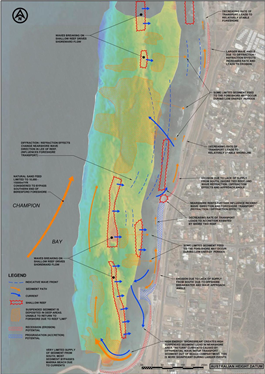 |
| Figure 2 - Coastal Processes that Occur Along the Beresford Foreshore |
Why is the detailed design different to the concept design?
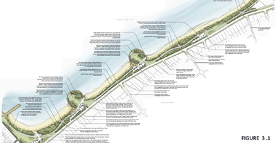 |
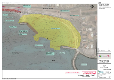
| Figure 3 - Beresford Foreshore Concept Design |
In 2012 the City, DoT and MWAP engaged Cardno to produce a concept design that focussed on adding value to the coastal protection elements of the project through the provision of additional land and beach amenity space (Figure 3). As part of the work undertaken during the design development and detailed design by Royal HaskoningDHV, additional nearshore bathymetry, wave and current data was collected, showing that extension to the offshore breakwater and the marina groyne were necessary. The concept design would have increase the amount of annual sand bypassing required, and created ongoing maintenance costs associated with the creation of an additional beach compartment.
Concept Design Report (Cardno 2012) (12MB)
The Concept Design Report with all appendices is available on request.
Based on the Council Resolution of 26 June 2012, the project was progressed to design development and detailed design.
Can you show me why the design needed to change?
The additional data collected and modelled shows the direction and size of the currents on the seafloor. With a headland structure (modified groyne) currents enter Midalia Beach from the northern end past the headland structure and sweep out past the marina groyne. The current is strong enough to move sand out of Midalia Beach and offshore (Figure 4). There is a hotspot shown directly off the marina groyne.
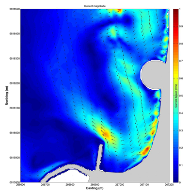 |
| Figure 4 - Modelling of Sand Movement - Concept Design |
By extending the offshore breakwater the direction and size of the currents entering and exiting Midalia Beach are modified (Figure 5). The hotspot disappears and the sand remains in Midalia Beach.
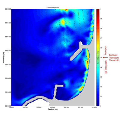 |
| Figure 5 - Modelling of Sand Movement - Final Engineering Design |
The extension to the marina groyne reduces the impact of waves scouring out the beach sand by the marina groyne.
Beach Profiles
By placing coarser grained sand at Midalia Beach (Figure 6), the beach profile will be kept within the confines for the coastal protection structures, which is not possible if using finer grained sand (Figure 7).
 |
| Figure 6 - Extent of Beach Profile - Using Coarser Grained Sand |
 |
| Figure 7 - Extent of Beach Profile - Using Finer Grained Sand |
Why is the Beresford Foreshore being protected anyway?
The City, DoT and MWAP engaged WorleyParsons to undertake a coastal processes study as part of the Costal Vulnerability and Risk Assessment Programme. This study assessed the coastline between the Greys Beach at Point Moore and Sunset Beach. It identified areas that are impacted by erosion and the Beresford Foreshore was one area that was vulnerable. An assessment of the infrastructure at risk was undertaken and showed more than $55M worth of infrastructure including gas, power, water and sewage lines, and footpaths were at risk if nothing was done. Other vulnerable areas were identified in the study, but did not have the same level of infrastructure at risk.
Coastal Processes Study (WorleyParsons, 2010)
The Coastal Processes Study with all appendices is available on request.
The feasibility of ten coastal management options was assessed during the study for the vulnerable areas identified:
|
Coastal Management Option
|
Feasible for Beresford
|
Description
|
|
Managed Recession
|
No, not progressed
|
Too much infrastructure at risk.
Lack of foreshore space.
|
|
Dune Management
|
No, not progressed
|
No dunes, coastline too modified.
Lack of foreshore space.
|
|
Beach Nourishment
|
Yes, considered
|
Lack of ongoing supply to sustain significant increase in nourishment.
Need to use in conjunction with other option.
|
|
Seawall/Buried Seawall
|
Yes, considered
|
Provides last line of defence.
|
|
Groynes
|
Yes, considered
|
Offers stabilisation to defined section of coastline.
|
|
Detached Breakwaters
|
No, not progressed
|
Effectiveness limited by variability in annual longshore transport.
|
|
Artificial Reefs
|
No, not progressed
|
Higher cost to implement with similar characteristics to groynes and breakwaters.
|
|
Beach Drainage
|
No, not progressed
|
Not efficient for moderate wave energy dominated beaches found in Geraldton.
|
|
Geotextile Sand Containers
|
No, not progressed
|
Uncertainty relating to technology.
Proximity to reef damaging GSCs.
|
Three coastal management options scenarios were presented to the community based on the coastal management options progressed above and in comparison with the existing sand bypassing scenario. The community preference was for the construction of a groyne, buried seawall, beach nourishment and ongoing sand bypassing.
Based on a Council Resolution of 9 November 2010 the project was progressed to concept design phase.
How does this sit with the State Coastal Planning Policy?
In line with the State Coastal Planning Policy the level of vulnerability of the Beresford Foreshore and the infrastructure at risk was assessed by the working group against the four themes of adaptation planning (avoid, managed retreat, accommodation, protection). The outcome was for protection given that there is sufficient justification that the risks cannot be avoided, accommodation measures alone cannot adequately address the risks and due to the modified nature of the coastline there was little scope for managed retreat.
The City has received $5,325,000 from Royalties for Regions for the implementation of Stage 1 of the multistage coastal protection and enhancement design solution to protect the foreshore and nearby infrastructure from erosion.