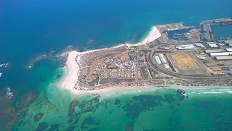
Point Moore Inundation & Coastal Processes Study
On 22 April 2014, Council resolved to undertake an inundation and coastal processes study of the Point Moore area to get a better understanding of the impact sea level rise, tides, storm surges, waves, Tsunamis, wind and climate cycles (El nino, La Nina)could have on the area.
The Point Moore Inundation & Coastal Processes Study is available as a summary report or full technical report below. .
Point Moore Inundation Summary Report
Point Moore Inundation & Coastal Processes Study Full Report
State Government Correspondence regarding the West End
Department of Lands
Department of Health
Department of Planning 1
Department of Planning 2
Department of Emergency Services
Frequently Asked Questions
Is there any way to slow down or stop the erosion or inundation?
There are a wide range of mitigation measures that could be taken to satisfy the City and State Government requirements such as raising the level of roads, installing rock barriers, improving dune stability etc… but these measures would come at great cost to the community.
Will the City be investigating mitigation measures bearing in mind there would need to be some contribution from the Commonwealth (Lighthouse) State (railway lines and the Southern Transport Corridor), Mid West Ports?
Protective mitigation measures are expensive and perhaps beyond even the contributions from those State and National stakeholders mentioned. Currently the City is in the consultation phase of this project. Future actions of the City will depend on the feedback received from the community and the results of the upcoming environmental study into the area's septic systems.
One of the mitigation measures being considered is to advise of the risk and keep people informed. The City is investigating the installation of signage in the near future and the release of the study and the public meetings are part of the disclosure process.
What has been the impact of the revetment recently constructed along Grey’s Beach? It appears that the Grey’s Beach shore has accreted since the wall was built.
The Grey’s Beach coastline is eroding not accreting. Observations show that in the Jurien Bay and Cervantes communities the southern side of their coastal areas are actually eroding and it is the northern side that is accreting. This is a trend that can be observed along the West Australian coastline.
Are the residents of the caravan park also affected?
The risk of coastal inundation is exactly the same for residents of the Life Style Village.
The Australian coastline is being inundated. What consultation will be entered into with other government bodies dealing with similar issues eg. Bunbury Council? Risk factors appear to not be predictive. To what extent will the potential risk impact on future developments?
The City has been in contact with other local governments faced with similar concerns and will continue to liaise in the future. However, the challenges local Governments are facing is individual to the area and community and need to be assessed accordingly. Based on the findings of the Point Moore Coastal Inundation Study and according to the State Coastal Planning Policy SPP 2.6 the State Government would not approve further development of the Point Moore area.
Who will be involved in the consultation process so that the opinions of the wider community are incorporated? How will the current timeframe enable this to happen?
The City will be undertaking Coastal Hazzard Risk Mapping Adaptation Planning in the coming months which will involve the broader community. If you would like to be involved in these workshops please contact Communications Officer - Engagement Janell Kopplhuber on 9956 6600.
Will the State Coastal Planning Policy SPP 2.6 be applied to new developments and retrospectively to existing developments throughout the whole of Geraldton?
The State Coastal Planning Policy SPP 2.6 is applied by the State Government to new developments and has been implemented across the City as per the Department of Planning requirements which included new subdivisions at Sunset Beach and Drummond Cove. The policy cannot be implemented retrospectively on existing developments but needs to be considered for the purposes of planning and appropriately managing risk of coastal inundation and erosion.
Statistically speaking, a 20 year ARI (average reoccurrence interval) event should have already occurred. In the past 20 years Point Moore hasn’t been flooded. What historical evidence is there of 20 and 100 year inundation events?
Although the road and the sand dunes have been protecting Point Moore from coastal inundation in the past, these barriers are considered too small or narrow by the WA Planning Commission to continue to provide protection to life and property in regard to inundation events that could occur somewhere between 20 and 100 year event estimates. What has happened over the previous 20 years is important but does not necessarily reflect what will happen over the next 20, 100, 500 years which the study needs to consider. Sea level rises are an important aspect to consider when looking at future events compared to previous events.
Does anyone really know what sea level rise will really be?
The State Government undertakes a climate change assessment every two years to track sea level rise and makes recommendations on coastal planning policy based on the rise in sea level. Since measurements have been taken sea level has risen .38m and if this trend continues sea level is expected to increase 0.9m over the coming 100 years.
Point Moore is repeatedly referred to as low lying so how does it compare to the rest of the CGG?
The land is unusual at Point Moore in that after an initial dune system the land drops to a low point of 1m above mean sea level. The majority of leasehold properties are below 3m above mean sea level. There are no unaltered coastlines in Geraldton where habitable buildings fall below 3m apart from two private residences in Bluff Point. Certain commercial sections of the CBD outside of the Port and Marine complexes are below 3m, but the coastline has been modified to accommodate potential risks.
When the tsunami came in nine years ago why wasn’t Point Moore affected?
The road provided a barrier to Pt Moore and prevented flooding from the tsunami referred to. However, the study indicates that cyclonic and non-cyclonic events will produce higher inundation levels than a tsunami. Storms and cyclones are associated with low-pressure systems which cause base water levels to be higher for example, for each 1Kpa drop in pressure water levels increase by 1cm. Therefore, a tropical low can increase water levels by 10-15cm. The Boxing Day tsunami was not associated with a low pressure system.
Since the lighthouse was built there has been no inundation event. Will this be taken into consideration in the decision making process?
The future of the lighthouse is a matter for the State Government as the City doesn't own the land or the building. However we would like to see this important iconic landmark protected.
Will the CGG consider entering a new 20-30 year lease arrangement so that residents can realise assets and develop a risk mitigation program and if not, will residents have to demolish their cottages at their own expense?
Council hasn’t made any decisions on the leases. Council wants to know what the risk of inundation and the environmental and health risks of current septic systems are before considering the matter further. Once the Residential Onsite Effluent Treatment and Disposal Study (ROETD) has been completed Council will be presented with the results of both studies and will be able to make an informed decision regarding leases.
What is wrong with the septic systems and what would need to be done to solve the issue?
The State Government has concerns about the condition of septic systems as there have been reports of systems failing. Therefore, the ROETD study needs to be undertaken to determine if this is the case and what, if any, environmental and health risks this poses to residents and the area.
Why do I pay rates and lease fees to live in Point Moore?
Rates and lease fees are two different things. If a person wishes to occupy land they do not own, it is standard practice for the owners to charge a fee for using the land. All land within a district regardless of whether it is leased or owned is rateable land. The Local Government Authority requires land to be valued prior to being disposed of by way of lease. The results of the valuations conducted by Landgate set the lease fees which are then resolved by Council.
What is the total income from Point Moore in terms of lease fees and rates?
The total income from leases for the 2015/16 financial year is $489,219.15 and the total rates levied for the 2015/16 financial year was $156,494.19. This sum does not include the Emergency Services Levy or fees for rubbish collection.
How much did this study cost ratepayers?
To date, the City has paid $84,850 for the Point Moore Coastal Hazard Risk Management and Adaptation Plan.