Geraldton CHRMAP Report FAQs
A number of questions regarding the Geraldton CHRMAP Report were submitted by the community during the public comment period and also submitted to Council for response at the 20 November 2018 Council Agenda Forum and the 27 November 2018 Ordinary Meeting of Council.
All of these questions are listed below. You can also download a PDF of the questions here
Frequently Asked Questions
1. Why were we not informed of coastal erosion or inundation issues when we bought our property a few of years ago?
The City made available coastal erosion and inundation maps on completion of each of the three Coastal Hazard Mapping projects. The reports and maps were published on the City’s website:
- 13 January 2016: Point Moore Coastal Inundation and Coastal Processes Allowances Study
- 6 April 2016: Town Beach to Drummond Cove Coastal Inundation and Coastal Processes Allowances Study
- 8 February 2017: Cape Burney to Greys Beach Coastal Inundation and Coastal Processes Allowances Study.
In addition to their publication on the City’s website, the City also notified local real estate agents, settlement agents, and REIWA informing them of the reports.
2. Why were subdivisions approved and houses built on the seaward side of the coastal setback lines?
Subdivision approvals issued by the State Government are determined on the setback requirements of the then State Planning Policy No. 2.6 – State Coastal Planning Policy in place at the time.
3. Given the setback lines are only modelled predictions, does the City plan to implement a monitoring program to track exactly what happens so adjustments to setbacks can be made?
Yes, one of the recommendations in the final draft Geraldton CHRMAP Report is for the City to undertake targeted beach monitoring at key coastal locations. This monitoring can be used to update the CHRMAP, which will is recommended to be reviewed every five years.
4. Will the City undertake any geotechnical and geophysical assessments and if so, will they be completed in time to inform policy development for properties identified at risk in the 2030 to 2110 timeline within Drummond Cove, Sunset Beach and Bluff Point coastal management units?
Yes, one of the recommendations in the final draft Geraldton CHRMAP Report is for the City to undertake geophysical investigations at key coastal locations and highlights the need for further studies at Bluff Point, Drummond Cove and Beresford. The results of these investigations will be used to inform the development of coastal adaptation policies. It should also be noted, the CHRMAP recommends the report be reviewed every five years.
5. The Economic Assessment identified “other intangible benefits and non-quantified benefits that were not assessed” and recommended if development of adaptation options progressed then further analysis could be undertaken to quantify some of these values. What measures will the City undertake to quantify the cost benefit analysis in relation to Tourism potential for Drummond Cove, being the northern gateway to the City of Greater Geraldton?
In recent times, the City has been involved in the development of the City of Greater Geraldton Growth Plan, the appointment of an experienced Economic Development Manager and the creation of a tourism cluster, which includes various local tourism operator representatives. These resources would most likely be used to determine the tourism potential of Drummond Cove with the outcomes considered during the future policy making process.
6. Why do coastal areas with high dunes have the same coastal erosion setback lines as coastal areas with low dunes?
Coastal erosion setback lines are based on the requirements of State Planning Policy No. 2.6 – State Coastal Planning Policy. The setback lines are developed by modelling the coastal processes occurring along the coast, and this changes from location to location. This means that areas with high dunes having the same vulnerability as areas with low dunes.
7. The CHRMAP showed that coastal erosion in Bluff Point has been negligible since approximately 1850 whilst other areas such as Sunset and Drummonds Cove are not so fortunate to have extensive reef that Bluff Point has that breaks the energy from the swell. Western Australia, through Recfishwest and the State Government, have built four artificial reefs nearly 10kms long at various locations at a cost of approximately $1million per reef. These reefs have been a huge success in allowing fish stocks and recreational fishing to flourish whilst driving tourism. Filling gaps in the reef with artificial reefs could be of great benefit not only to the survival of our beaches and coastline but could bring added benefits in forming fishing reefs for divers and fishermen as well as better waves for surfers, paddle boarders ,windsurfers and other water users. Could similar structures along our coast, which could also be used to infill places where the reef is missing, be considered?
This idea could be investigated as part of the policy development phase of this project. The Geraldton CHRMAP Report recommends several adaptation and resilience measures considered appropriate to the Geraldton coast by professional coastal engineers, including the long-term adaptation pathways that the City and its community can adopt to become more resilient to coastal hazards such as coastal erosion and coastal inundation. A potential issue with this option may be its effectiveness to mitigate the 0.9m sea level rise and the State Planning Policy No. 2.6 – State Coastal Planning Policy requires to be taken into consideration. Council’s adoption of the Plan will allow the progression of further detailed studies, investigations and community consultation to refine the location of the coastal setback lines, seek formal funding advice from the State Government and the development of local coastal planning policies to address the potential impacts of long-term climate change. The report is a strategic document that recommends specific investigations and ongoing monitoring actions to continue to inform a five-yearly review of the plan and recommended actions. Further consultation with the community is proposed in Stage 3, during the development of a local coastal planning policy, and community ideas and suggestions will again be collated for consideration during this process. In regard to coastal erosion being negligible since 1850, the probable primary difference between the last 100 years and the next 100 years is the requirement to manage a 0.9m sea level rise.
8. Geotextile groynes appear to work in the same way as an artificial reef. The groynes extending from the shore out into the sea don’t appear to work because they are supposed to be helping sediment to build up but in the case of our coastline, the harbour and town development has prevented the sediment being deposited anywhere near our areas. Would it not be more viable to place structures horizontal to the coast and between the shore and the shipping channel in order to reduce the impact of the swell coming out of the deepened channel?
This idea could be investigated as part of the policy development phase of this project. Generally, along the Geraldton coastline, there is a northerly drift of sand. The Port, as part of their development annually bypass 12,500 cubic metres of sand, picked up from south of the Port and deposited at the Beresford foreshore or Bluff Point. The sand bag groyne at Rundle Park mimics the old boat ramp. Residents advised that when the boat ramp was removed, the erosion increased. Coastal experts suggested the city trial the groyne where the boat ramp was located. The City sought further advice and is also installing two similar sand bag groynes at Drummond Cove. If they are not successful, they can be removed. The Geraldton CHRMAP Report recommends several adaptation and resilience measures considered appropriate to the Geraldton coast by professional coastal engineers, including the long-term adaptation pathways that the City and its community can adopt to become more resilient to coastal hazards such as coastal erosion and coastal inundation.
9. Responsibility for increased erosion has been admitted by the Port and the Geraldton Guardian has claimed the City is also responsible for the increased erosion due to the works at the Foreshore. Why does the CHRMAP report not take into account sand replenishing, man-made modifications, etc… in its calculations for erosion?
The Geraldton CHRMAP Report takes into account existing treatments such as the Northern Beaches Stabilisation Programme (NBSP) sand bypassing works undertaken each year by the Mid West Ports Authority and the Beresford Foreshore coastal protection structures have been designed not to interrupt the sediment flow northwards from Beresford.
10. The fringe reef platform along the coast currently provides an effective barrier to alleviate the erosive forces of wave impact on beaches and the necessity for hard onshore construction that may compromise the quality of our beaches. Given it is widely accepted and acknowledged in reports that the infrastructure constructed on the shoreline and into the waters of Champion Bay, as well as the widening and deepening of the shipping channel has significantly impacted the natural sand replenishment on the norther beaches of the Geraldton coastline, will the Council support the community in canvasing the State Government to protect the already established suburbs by increasing and consolidating the fringe reef platform?
Yes, Council’s adoption of the Geraldton CHRMAP Report will enable the CEO to seek formal advice from the State Government on its position with respect to the future availability of funding for coastal protection works. The advice received from the State will guide Council’s subsequent response. The City will also canvas the State and Federal Governments for funding for any possible coastal works but cannot comment yet on what form the coastal works would take.
11. Why does the CHRMAP Report rely on officially accepted climate models, which have been proven by long-term Australian tide gauge records to be a serious exaggeration of global warming causing sea level rise?
The Geraldton CHRMAP Report is based on the requirements of State Planning Policy No. 2.6 – State Coastal Planning Policy. The Report focusses on the consequential impacts of sea level rise, not the causal effects. If sea level rise predictions change significantly, then this will be reflected through State Planning Policy No. 2.6 – State Coastal Planning Policy.
12. Table 5.5 in the report refers to the LiDAR capture date of March 2013. Aerial data used was from 2016. Given the Beresford works has only just been completed, is the Council planning on requesting updated LiDAR captures and aerial data to then ask Baird to prepare an updated report based on the latest data available?
The Geraldton CHRMAP Report has been undertaken as per the requirements of State Planning Policy No. 2.6 – State Coastal Planning Policy. The plan is a strategic document that recommends specific investigations and ongoing monitoring actions to inform a five-yearly review of the plan and the adoption of the Geraldton CHRMAP Report is not the conclusion of this project. The final draft Geraldton CHRMAP Report recommends undertaking key technical studies to further inform the ongoing CHRMAP process such as a geophysical survey of the shoreline and more detailed overland flood studies. The City has allocated $600,000 in its FY2018-19 budget towards CHRMAP Adaptation Measures. Of this budget, $240,000 has been committed to coastal adaptation works at Whitehill Road, Drummond Cove. The residual budget could be allocated to implementing the recommended investigations, studies and monitoring following adoption of the final draft Geraldton CHRMAP Report.
13. According to the CHRMAP report, Southgate Dunes will help protect the Tarcoola Beach from coastal erosion for another 50 years. So why is the City allowing the continued mining of sand from these dunes?
The section of Southgate Dunes that is contributing to the supply of sand feeding the beaches north of the dune system is not being mined, and those areas will not be mined going into the future.
14. Since the release of the CHRMAP Report, my insurance premiums have increased. Is there anything the City can do to reassure insurance companies that my property isn’t at risk?
The development of the coastal hazard maps for Geraldton are based on the requirements of State Planning Policy No. 2.6 – State Coastal Planning Policy. One of the recommendations in the report to Council is to undertake further Geophysical investigations that may result in changes to the erosion lines. Further information on the role of the insurance in coastal adaptation can be found here
15. A key factor in estimating erosion levels and the potential for rock to limit the impacts of coastal erosion is the presence of bedrock. Why does the modelling not mention this?
The development of the coastal hazard maps for Geraldton are based on the requirements of State Planning Policy No. 2.6 – State Coastal Planning Policy. This means the Geraldton coastline is treated as a sandy coast. One of the recommendations in the report to Council is to undertake Geophysical investigations at key coastal locations that may allow certain coastal locations to be treated as rocky. If this is the case, the erosion set back lines may be able to be adjusted.
16. The Geraldton Port and the Batavia Coast Marina are the cause of the coastal erosion issues, and that the coastal erosion setback lines wouldn’t be so bad if the Port and Marina breakwaters hadn’t been built. Will the Port be funding the required coastal protection works that their actions have caused?
The Port has recognised its contribution to erosion to the northern beaches up to the Chapman River and is obliged to bypass 12,500m3 of sand each year to the Beresford Foreshore to feed these beaches. It has undertaken this operation since 2006 – and this will continue into the future.
17. In 2003, a MOU was implemented between Mid West Ports Authority and the City Council regarding the impact dredge works and groyne structures were having on the Champion Bay Coast line. Over the last 20 years sea level rise has been minimal and most erosion has come for storm activity made more severe by deepening the shipping channel and groyne building. Therefore, does Council, on behalf of its residents, believe the undertaking of sand nourishment by the Port is adequate and should the Port be contributing more towards coastal erosion?
Coastal erosion and inundation is impacting coastlines around Australia including Geraldton. To that end, the Mid West Ports Authority has recognised its contribution to erosion to the northern beaches up to the Chapman River and since 2006, has been bypassing a minimum of 12,500m3 of sand each year (a figure calculated at that time by one of Australia’s leading coastal engineers)) to the Beresford Foreshore to feed these beaches and this will continue into the future. The Port has also help fund the construction of coastal protection works along the Beresford Foreshore and we are grateful for their contribution towards this project. The City will continue to work with the Port regarding potential projects to mitigate the impacts of coastal erosion and inundation if and when infrastructure becomes at risk.
18. Why has there has been a complete lack of transparency and communication regarding the development the CHRMAP Report.
The development of the Geraldton CHRMAP Report has had extensive community consultation, which was widely promoted. Promotion of the process began with the release of the three Coastal Hazard Mapping reports covering the area from Drummond Cove to Cape Burney, which included community information sessions regarding the reports.
19. How can the City say the CHRMAP report was informed by community engagement when they only promotion of the topic was a social media post and the City website?
A flyer regarding the Coastal Planning Survey and Workshops planned for the CHRMAP project was distributed to all property owners in the July 2017 Rates Notices. Extensive information on CHRMAP and related issues including workshop dates and how/where to take the survey were uploaded to the City’s website. A range of media releases and social media posts were issued and posters displayed at key locations across the City and extensive advertising campaigns in both traditional and social media platforms were undertaken to promote the community survey and workshops. A complete summary on the Community Engagement process undertaken to inform the Geraldton CHRMAP Report development is available on the City website here
20. Some public comment submissions indicate perceived gaps in community engagement for the CHRMAP process to date so how is the City planning to identify and address any gaps for Stage 3 of the process?
Once the Geraldton CHRMAP Report is adopted by Council, Stage 3 of the process can begin and a Community Engagement Strategy for policy development will be developed. Opportunities for the community to have their say will be promoted using a range of traditional and social media channels including media releases and the City website. To ensure opportunities to engage aren’t missed, the City encourages residents to regularly visit the City’s website where all the latest news and information on all community engagement activities can be easily found.
21. Chapman Valley Shire residents come to Geraldton to visit our beaches all the time. Why weren’t they included in the consultation process?
The development of the Geraldton CHRMAP Report has had extensive community consultation, which was widely promoted. Chapman Valley Shire has been included in the stakeholder engagement. Community feedback has not been restricted to residents of the City of Greater Geraldton.
22. Why does the report recommend managed retreat and not reflect what was reported in the Coastal Planning Community Workshops Summary Report regarding protection of homes?
The CHRMAP Community Workshops were undertaken to provide the opportunity for the community to identify and prioritise assets in the coastal zone and the importance of these assets to them. The CHRMAP Community Workshops also explained the coastal adaptation types and provided the opportunity for the community participants to suggest adaptation measures for each adaptation type. This provided information for the consultant to identify the long-term adaptation pathway for the assets and values in the coastal zone.
23. I attended the community workshop in October 2017 and managed retreat by Sunset Beach residents was not an option so why does it appear in the CHRMAP report?
The CHRMAP Community Workshops were undertaken to provide the opportunity for the community to identify and prioritise assets in the coastal zone and the importance of these assets to them. The CHRMAP Community Workshops also explained the various coastal adaptation types and provided the opportunity for the community participants to suggest adaptation measures for each adaptation type. This provided information for the consultant to identify the long-term adaptation pathway for the assets and values in the coastal zone.
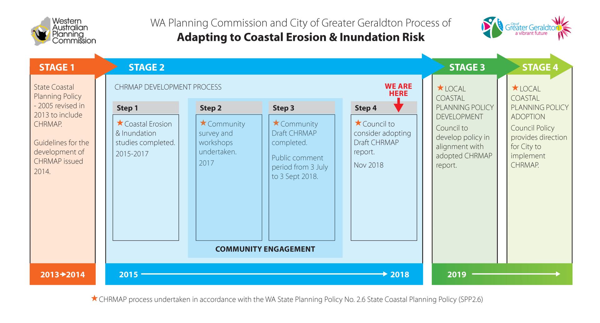
24. What are the timelines for development of coastal planning policies?
The timeline for the development and adoption of coastal adaptation policies is outlined below.
here
25. Given the varied projected impacts of erosion and inundation within the boundaries of the City of Greater Geraldton, how is the City planning to develop policy that is appropriate to specific areas of risk?
The City agrees that different impacts have been identified at different locations along the Geraldton coastline. The Council has not yet decided on the framework for the coastal adaptation policy development stage of the project. Possible options include having individual policies for the 12 coastal cells, grouping the cells into four geographical areas with a policy each area or having one overarching policy establishing the general direction for specific strategies within each cell.
26. Will those impacted by erosion and inundation be included in policy development?
The City will continue its extensive community engagement through the development of coastal planning policies.
27. There have been quite a few properties built lately in the area the CHRMAP Report says are in the extreme risk or near to it. How does the Council justify allowing more development in an area they already know is at risk and yet not make the current situation known to those buyers?
The potential impacts of coastal erosion and inundation on the area between Cape Burney and Drummond Cove has only been known to the City since three coastal erosion and inundations studies of the area were completed. These reports have been available to the community on the City’s website since the following dates:
- January 2016: Point Moore Coastal Inundation and Coastal Processes Allowances Study
- 6 April 2016: Town Beach to Drummond Cove Coastal Inundation and Coastal Processes Allowances Study
- 8 February 2017: Cape Burney to Greys Beach Coastal Inundation and Coastal Processes Allowances Study.
In addition to their publication on the City’s website, the City also notified local real estate agents, settlement agents, and REIWA informing them of the reports.
Under the State Planning Policy 2.6 State Coastal Planning, the Geraldton CHRMAP Report recommends development approval on land that is considered infill development within Special Control Areas under an accommodate and managed retreat approach with mechanisms that address the identified risk. Coastal adaptation policies, which will be developed in Stage 3 of the Coastal Adaptation Process, will determine what these mechanisms may be.
28. Will I still be able to build a house on my vacant block of land now that it is located behind the red line?
Under the State Planning Policy 2.6 State Coastal Planning, the CHRMAP Report recommends that development approval be required on land that is considered infill development within Special Control Areas under an accommodate and managed retreat approach with mechanisms that address the identified risk. Coastal adaptation policies, which will be developed as in Stage 3 of the Coastal Adaptation Process, will determine what these mechanisms may be.
29. Will the City still issue building permits for me to renovate my existing house now that it is located behind the red line?
The issuing of building permits to undertake renovations on existing houses located within the Special Control Area may be subject to a separate development approval process (to accommodate and managed retreat mechanisms outlined in the State Planning Policy 2.6 State Coastal Planning that address the identified risk). The Coastal Adaptation policies, which will be developed as in Stage 3 of the Coastal Adaptation Process, will determine what these mechanisms may be. *Note: Cannot apply controls on building permits under the legislation.
30. Is the City planning on changing the ability of homeowners in the extreme risk category to be able to demolish and build on their land, and will there be consultation with the affected homeowners prior to such decision?
Under State Planning Policy 2.6 State Coastal Planning, the CHRMAP Report recommends development approvals on land that is considered infill development to be undertaken within Special Control Areas under an accommodate and managed retreat approach with mechanisms that address the identified risk. Coastal adaptation policies, which will be developed as in Stage 3 of the Coastal Adaptation Process, will determine what these mechanisms may be. The policy development phase of this project will include further consultation with affected land and homeowners.
31. Why would the City want to set a precedent by establishing Special Control Areas?
Special Control Areas (SCAs) are intended to control particular types or characteristics of development associated with a circumstance which does not generally coincide with an existing zone or reserve. Special Control Areas can be used to address a range of issues including: bush fire prone areas, flood prone land, minerals and basic raw materials, landscape protection, sensitive development buffers, water catchments, and areas of special character. Local Planning Manual (WAPC, 2010). The City already has seven Special Control Areas. These can be viewed on the City’s public Intramaps portal (https://maps.cgg.wa.gov.au/Intramaps90).
32. Is the Council planning that properties at extreme risk be listed with a Section 70A notification on their title and will this be communicated in writing first to the affected property owners?
At this point in time, no decision has been made by Council on any planning controls (including the possibility of notifications on title) as part of the CHRMAP process. Coastal adaptation policies, which will be developed in Stage 3 of the Coastal Adaptation Process, will determine what these planning mechanisms may be. The policy development stage of this project will include further consultation with affected land and homeowners.
33. Given that many, if not all properties identified as at risk in the CHRMAP have a similar, equal or higher AHD than properties in the CBD and Beresford, and that the latter mentioned properties will therefore be affected by any possible sea level rise before those as unprotected, does the Council accept that it is unreasonable to place Section 70A notifications on some properties and not the others?
At this point in time, no decision has been made by Council on any planning controls (including notifications on title) as part of the CHRMAP process. Coastal adaptation policies, which will be developed as in Stage 3 of the Coastal Adaptation Process, will determine what these mechanisms may be. The policy development stage of this project will include further consultation with affected land and homeowners. With respect to coastal process implications, if Council decides that placing notifications on properties is appropriate, this would need to be done equitably. Please note that a property’s AHD is not the only factor that determines how a property is impacted by coastal erosion processes.
34. Is the City prepared to undergo lengthy legal action and the associated costs should Section 70A notifications be placed on titles?
At this point in time, no decision has been made by Council on any planning controls (including notifications on title) as part of the CHRMAP process. State Planning Policy No. 2.6 – State Coastal Planning Policy states:
Where a coastal hazard risk is identified, it should be disclosed to those likely to be affected. On consideration of approval for subdivision and/or development current and/or future lot owners should be made aware of the coastal hazard risk by providing the following notification on the certificate on title: VULNERABLE COASTAL AREA –This lot is located in an area likely to be subject to coastal erosion and/or inundation over the next 100 years.
35. What will happen to homes resumed into public domain?
At this point in time, no decision has been made by Council on resuming property into the public domain.
36. Where will people go when their houses are resumed into the public domain?
At this point in time, no decision has been made by Council on resuming property into the public domain.
37. How can the City adopt a managed retreat stand when they have obligations to land owners under the Planning Act?
The Geraldton CHRMAP Report is based on the requirements of State Planning Policy No.2.6 - State Coastal Planning Policy. The report looks at the potential risks to twelve Coastal Management Units over three planning timeframes which will guide sustainable decision-making over the coming years.
38. If the Accommodate / Managed Retreat option is kept in place, will the COGG be prepared to purchase our properties at our current asking price?
At this point in time, no decision has been made by Council on resuming property into the public domain.
39. The CHRMAP Report says more than 600 properties will be impacted by coastal erosion over the next 100 years and the estimated value of properties is approximately $36,000,000. Wouldn’t it be cheaper to protect these properties rather than resume them?
It is important to differentiate between assets that are likely to be at risk between now and 2030 and assets that may be at risk in the future (2030 – 2070). The Geraldton CHRMAP Report is based on the requirements of State Planning Policy No.2.6 - State Coastal Planning Policy. The report looks at the potential risks to twelve Coastal Management Units over three planning timeframes which will guide sustainable decision-making over the coming years.
40. Why would the City choose not to protect coastal properties when it is the least costly? ‘Do Nothing’ will incur reputation damage and legal costs to the city, detour tourism and investors and incur legal costs ‘Planned Retreat’ requires reserve funds to acquire the properties before or at the time of the erosion trigger whereas ‘Protect’ has the least cost and risk and the biggest reward to the community and stakeholders whilst encouraging tourism and investment.
The Geraldton CHRMAP Report is based on the requirements of State Planning Policy No.2.6 - State Coastal Planning Policy. The report looks at the potential risks to twelve Coastal Management Units over three planning timeframes which will guide sustainable decision-making over the coming years.
41. As it seems the majority if not all residents affected by any proposed Section 70A notifications on properties favour protection measures to be implemented to the section of coastline north of John Batten hall. I would like to propose an all-weather boat ramp to be included in any works north of John Batten Community Hall. Geraldton has no all-weather boat ramp north of town and desperately needs one. This would not only be a great benefit to the local community but would be excellent way to promote tourism north of the town centre. This ramp would also increase the safety for boat owners as they would no longer have to tackle the risks with beach launching and the Geraldton Sea Rescue could also access the ramp in case of emergency. Is council aware of the Recreational Boating Fund and will you be using it to fund any protection measures along this stretch of coastline?
The City is aware of the Recreational Boating Fund (RBF) and supported the Drummond Cove community in 2017 with an application to Round 22 for the design and construction of a boat launching facility at Whitehill Road. MP Rogers & Associates were engaged by the City to undertake concept design investigations and cost estimates into an enclosed boat launching facility subsequent to a review of boat ownership rates and usage in Geraldton in 2013 that suggested a potential need for two new lanes of boat ramp by 2026. The concept design and estimate cost of an enclosed boat launching facility are in the order of $4.2m however, only a maximum of $750k is available from RBF.
- The City was unsuccessful in its funding application, but the feedback received was that:
- This would be a worthy project however agreed that further study/planning was required.
- The location is an erosion hotspot area and further investigations are required prior to consideration of any boating facilities.
- This is a large project and would require capital funding and a staged approach.
This option could again be considered when the CHRMAP report has been adopted and the State Government’s position on funding coastal protection works is clearly understood. A copy of the MP Rogers & Associates concept design report is available on the City website here
42. The City has already set a precedent by funding coastal protection works at Beresford Foreshore. Why is the Council not considering protection for the remainder of the coastline to the north?
The primary driver for the Beresford Foreshore Project was to protect State and Local Government assets and utilities located along Chapman Road valued at more than $55M, which were at risk from coastal erosion. The project was funded through the Royalties for Regions funding and Mid West Ports Authority. The City committed $1.85M to replace and improve amenity lost to coastal erosion. In line with the State Planning Policy 2.6 State Coastal Planning, the Beresford Foreshore coastal protection works were progressed only after all other options for avoiding and adapting to coastal hazards including managed retreat had been fully explored.
43. As stated on 27 October 2015, the City’s position pertaining to the almost completed coastal protection measure installed on Beresford Foreshore, is that the works ‘will provide protection to Local and State government owned infrastructure such as roads, electricity, water supply, sewerage and telecommunications. This infrastructure provides benefits to all residents and not just those in the immediate vicinity. Similarly, any improvement in amenity will also benefit all residents and visitors to our City’. Given that the community consultation phase of the CHRMAP process identified that most of the wider community identifies the beaches as City’s the most important asset, will the City reject the proposal within CHRMAP that those properties immediately protected be required to pay for the protection works (that benefit the greater community)? If not, will all properties in Beresford be required to fund the protection works.
The primary driver for the Beresford Foreshore Project was the protection of State and Local Government assets and utilities located along Chapman Road valued at more than $55M, which were at risk from coastal erosion. The project funding of $23m was provided through Royalties for Regions, Mid-West Ports Authority and a City contribution of $1.85M to replace and improve amenity previously lost to coastal erosion. State funding bodies are increasingly requesting a strategic Coastal Adaptation Plan and local coastal planning policies to demonstrate the need, and planning undertaken for coastal adaptation measures. Formal adoption of the Geraldton CHRMAP will progress the investigation of opportunities for access to funding for coastal adaptation measures. No decisions will be made as to how funding may impact the Geraldton community until the State’s position is understood.
44. One of the options in the CHRMAP is that any protection works for potential sea level rise and coastal erosion can be funded in part by, or charged to, the residents whose properties are protected. Can Council confirm how much the residents of Beresford have been charged or are going to be charged in their rates for the protection of the Beresford Foreshore?
The Beresford Foreshore Project funding of $23m was provided through Royalties for Regions, Mid West Ports Authority and with a City contribution of $1.85M to replace and improve amenity previously lost to coastal erosion. No residents in Beresford have received any additional rates or charges to contribute to the project costs.
45. Is Council aware that Geotextiles Sand Containers are made of polyester, which will ultimately break down into plastic particles adding to environmental plastic load and if so can alternative materials be considered, included in CHRMAP Report and then sourced and installed?
The City is always looking for ways to reduce its environmental impact. For instance, the City is now using hessian bags around its plantings instead of plastic following concerns raised by the community. With respect to the Geotextile Sand Containers, they have been placed with the aim of minimising environmental and coastal harm. It is envisaged, if the bags begin to deteriorate or it is determined that their placement is not producing the desired result they will be removed and disposed of appropriately. Alternative materials such as rock, concrete, timber and composites have and are being investigated. For example, the City has sought advice regarding adaptation works at Sunset Beach. The advice received from M P Rogers and Associates is available on the City website: here
46. The Geraldton Foreshore has been fortified for erosion, but the CBD faces an inundation risk. Can a low dike along the foreshore be included in the potential management and adaptation response, which would reduce inundation risks for the CBD and residential areas?
The City is currently preparing for a grant funding application to be submitted to further investigate the inundation risks the CBD area faces, and what measures could be taken to reduce the risk. Further information will be available when the grant announcements are made, and the study completed.
47. Why should property owners have to pay for coastal protection works when Beresford Residents didn’t have too?
The primary driver for the Beresford Foreshore Project was to protect State and Local Government assets and utilities valued at more than $55M.
48. Has the City commenced negotiations with the State Government regarding their assets identified at risk in the CHRMAP so collaborative joint venture projects, which could provide cost effective protection works for State and Federal Treasuries, can be developed? If yes, what has been the response?
The Council’s position is that it would like to work collaboratively and cooperatively with all asset owners potentially impacted by coast processes. The City has demonstrated its willingness to do this with the completion of the recent Beresford Foreshore works. With respect to access to future State and Federal Government funding for coastal protection works, officers have been advised that the first step is the adoption of the CHRMAP Report by Council. The proposed Council resolution reflects the desire to obtain assistance from both the State and Federal Governments on this issue which is being faced by coastal councils around Australia. As a specific example, at the time of the closure of Whitehill Road, officers approached various utility providers for assistance with funding coastal works. On this occasion the City was unsuccessful with these organisations as they opted not to remove their infrastructure and adopted a wait and see approach.
49. How can we, the Community, support the City in efforts to attract funding for coastal protection works?
Community efforts to attract funding for coastal works would be greatly appreciated. A good place to start would be to raise your concerns with your local State and Federal Government members directly. The City will also itself once the CHRMAP report is adopted.
50. I pay high rates on my property, can this money be quarantined to fund coastal protection works?
Rates collected by the City fund the annual provision of a multitude of services across the City region. Differential general rates are paid by all urban ratepayers, on the basis of gross rental valuations of properties, to that end. A specified area rate could be implemented for properties in impacted zones but that would usually be in addition to the general rates. At this stage, it is too early to consider such options, and the Council has not considered such options, pending completion of the remaining stages of the CHRMAP process.
51. Can more coastal protection similar to Greys Beach and St Georges Beach be implemented along all the northern beaches to protect homes?
Once the Geraldton CHRMAP report is adopted, Stage 3 of the Coastal Adaptation Process can begin which involves the development of coastal policies which will include what adaptation measures will be applied to mitigate coastal erosion and inundation within the 12 cells. Once this has been determined, the City will be able to undertake further work to progress coastal adaptation works in key coastal areas.
52. Is the City considering creating a Council committee to deal with coastal erosion and if so would it be possible to have two or three residents on it?
A new Council committee or any type of advisory/reference group the formation would have to align with Council Policy CP4.4 - Establishment and Operation of Committees and Council Policy CP1.6 – Community Engagement and the Community Engagement Framework both of which outline conditions of membership.
53. When will works commence on road connectivity between Waterfront Circle and Drummond Cove Road?
The results of the Whitehill Road Realignment Survey, undertaken in May 2018 to determine whether the local community wanted to re-establish connectivity between John Batten Community Hall and Drummond Cove Road, were presented at the July 2018 Ordinary Meeting of Council where Council resolved to:
- RECEIVE the Whitehill Road Realignment Survey Report; and
- DEFER determination of a connectivity option until the CHRMAP process is complete and the outcomes of coastal protection works (including the proposed geo—textile groynes) are clear.
In accordance with this resolution, officers are currently advancing the CHRMAP process and the installation of the sandbag groynes. This will enable officers to re-present the road connectivity issue for Council’s consideration. Unfortunately, a timeframe for when this will occur has not been established.
54. Would the City consider the connectivity road be constructed to minimise the impacts to residents by setting the road traffic for ‘local traffic only’ at reduced speeds?
Prior to the closure of Whitehill Road, the traffic volume was approximately 200 vehicles per day. This is not a large traffic flow. The City is not aware of issues associated with traffic volume or speed along this section of road. The issue brought to the City’s attention by the local community is the use of unregistered vehicles. The City could erect signage to try and control the behaviour of road users, but history shows that this has limited success. Use of a road is best controlled by its alignment, width and location.